The map below shows the current U.S. Intercontinental Ballistic Missile (ICBM) missile silos. You can scroll and zoom this map to see individual missile silos. The control in the upper-right corner of the map (it shows the four corners of a box) allows you to see the map full-screen. The markers are color-coded by ‘flights’. Each flight is a group of 10 missile silos controlled by a Missile Alert Facility (MAF).
Help using Google Maps
The Full Screen control in the upper righthand corner of the Google Maps display expands the display to cover the entire computer screen. This full-screen feature is not available on Apple IOS devices like the iPad.
You can exit out of full screen by pressing the Escape key or clicking the control in the upper righthand corner of the display.
The Map/Satellite control in the upper lefthand corner of the screen lets you choose either the normal map view or the satellite view. The satellite view allows you to see the actual military facility when you zoom in. You can choose to turn Labels on or off. The labels are the names of places, businesses, cities, etc. that appear on the map. You can turn off the labels if they obstruct your view.
When you select the Map view, you can turn on terrain features by clicking or touching the Terrain box. This will show things like mountain ranges, similar to looking at a relief map.
You can zoom in and out in a few ways. If you're using a mouse with a scroll wheel, the wheel controls zooming. If you're using an IOS device like an iPhone or iPad, double-tapping the display zooms in but tapping does not zoom out.
Most touch screen devices will zoom by pinching the display with two fingers.
There were more active silos in the past. Silos have been deactivated because of treaty obligations, missile obsolescence, and Congressional belt-tightening. Deactivated silos were located in Arizona, California, Idaho, Kansas, Missouri, Montana, Oklahoma, New York, South Dakota, Texas, and Washington. You can see the locations of all silos on the Cold War ICBM Silos page.
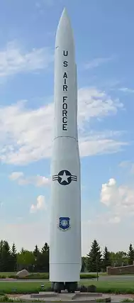
All missiles in the silos are currently Minuteman III (LGM-30G). It has a maximum range of 6,200 miles and a maximum speed of Mach 23 (17,500 mph). Launched from a Montana silo, a Minuteman III would take about 20 minutes to reach Moscow—its speed is not constant along its flight path.
The Minuteman III has an inertial navigation guidance system that is entirely internal. It does not rely on GPS or visual sighting to strike its targets.
A missile may have a MIRVed warhead, containing three W78 350-kiloton warheads, to attack three targets. Optionally, a missile may contain a single W87 475-kiloton warhead to attack a single target.
Note: The Little Boy bomb dropped on Hiroshima on August 6, 1945 had a yield of 15 kilotons. The Fat Man bomb dropped on Nagasaki on August 9, 1945 had a yield of 20 kilotons. Today's W78 warheads are 23 times more powerful than the bomb dropped on Hiroshima.
Missile Alert Facilities
Underground launch control centers, called Missile Alert Facilities (MAF), that are within miles of the missile silos, control missile launch for 10 silos normally, and up to 50 silos if necessary. The MAF and its ten silos is called a ‘flight’. If those centers fail to carry out a launch order, specially-configured E‑6B airborne command posts, nicknamed ‘Doomsday Planes’, can take over.
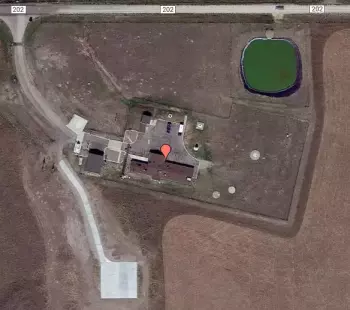
Figure 2 shows a satellite view of a MAF. The central buiding houses the elevator to take the missileers down to the underground control center. Ther are also sleeping quarters and eating areas above ground. There's a garage for vehicles. The green pond in the upper-right of the photo is the ‘poo pond’ that processes waste. A helicopter pad is shown in the lower portion of the photo.
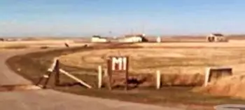
Figure 3 shows a Google Maps street-view of the entrance to a MAF. This is the entrance to the 341st Missile Wing, 490th Missile Squadron M-01 in Monroe, Montana off of Interstate 87. The sign simply says M1. The security gate to the MAF is 968 feet from the road.
Each MAF normally commands the missiles in 10 silos but any one MAF may control 50 silos if needed.
Missileers
The people who work in the Missile Alert Facilities are called missileers. Until 1978, all missileers were men. The National Park Service has a history of how women became missileers. Figure 4 shows an underground launch control center.


Silos
Not all silos have missiles. Press reports and Pentagon briefings have put the number of ICBMs at 400. So, 50 silos are empty, but the enemy may have a difficult time knowing which ones.
Figure 6 shows satellite views of a normally unattended silo (left) and one undergoing maintenance (right). Although silos are unattended, they are monitored with video and other intrusion detection mechanisms.
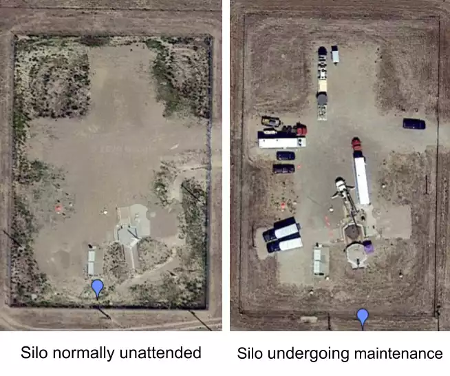
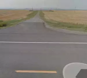
Figure 7 shows a missile silo site from the road. This silo's security gate is 547 feet from the road. If you were driving by and you didn't know it was there, you'd probably ignore it.
Sources
ICBM History lists all the past and present ICBM silos and displays a map of them.
Alert Operations and the Strategic Air Command
Wikipedia: Missile launch control center
This is What It’s Like to Be in Control of the Most Powerful Weapons on the Planet
New ICBM Replacement Cost Revealed
U.S. ICBM to Replace 1970s Minuteman May Cost $111 Billion
The cost of a new ICBM is going up. Here’s why the US Air Force isn’t concerned.
The Cost of U.S. Nuclear Forces: From BCA to Bow Wave and Beyond