Help using Google Maps
The Full Screen control in the upper righthand corner of the Google Maps display expands the display to cover the entire computer screen. This full-screen feature is not available on Apple IOS devices like the iPad.
You can exit out of full screen by pressing the Escape key or clicking the control in the upper righthand corner of the display.
The Map/Satellite control in the upper lefthand corner of the screen lets you choose either the normal map view or the satellite view. The satellite view allows you to see the actual military facility when you zoom in. You can choose to turn Labels on or off. The labels are the names of places, businesses, cities, etc. that appear on the map. You can turn off the labels if they obstruct your view.
When you select the Map view, you can turn on terrain features by clicking or touching the Terrain box. This will show things like mountain ranges, similar to looking at a relief map.
You can zoom in and out in a few ways. If you're using a mouse with a scroll wheel, the wheel controls zooming. If you're using an IOS device like an iPhone or iPad, double-tapping the display zooms in but tapping does not zoom out.
Most touch screen devices will zoom by pinching the display with two fingers.
Lend-Lease
The American Lend-Lease program supplied the Soviet Union with a huge amount of armaments and supplies. In addition to the aircraft listed in the table below, it included about:
- 400,000 trucks
- 12,000 tanks and other combat vehicles
- 32,000 motorcycles
- 51,000 Jeeps
- 13,000 locomotives and railway cars
- 8,000 anti-aircraft cannons
- 132,000 machine guns
- 40,000 field radios
- 400 radar systems
- 400,000 metal-cutting tools
- 4.5 million tons of food
- 107 million tons of cotton
- 15 million pair of army boots
- massive amounts of steel, other metals, oil and gasoline, and miscellaneous chemicals.
The number of aircraft is disputed. Here's one breakdown that seems like a reasonable estimate, but some estimates are twice this amount:
| 2,618 | Bell P-39 Airacobra fighters |
| 2,397 | Bell P-63 KingCobra fighters |
| 1,363 | Douglas A-20 Havoc attack aircraft |
| 732 | North American B-25 Mitchell medium bombers |
| 710 | Douglas C-47 Skytrain transports |
| 54 | AT-6 Texan trainers |
| 48 | Curtiss P-40 Warhawk fighters |
| 30 | Catalina PBY amphibian patrol aircraft |
| 3 | Republic P-47 Thunderbolt fighters |
| 1 | Curtiss C-46 Commando transport |
Because of the threat of German U-boat attack, most of the airplanes supplied to the Soviet Union were flown there by ferry pilots using the route called ALSIB, which stands for Alaska-Siberia. About 47 percent of other materiel was transported to the Soviet Union via West Coast U.S. ports to Eastern Siberian ports and the relative safety of the Pacific Ocean and Bering Sea. Japanese submarine doctrine focused on sinking military ships, not merchant ships like the Nazi subs in the Atlantic.
There were numerous ferry routes. There was a northern route that involved crossing Greenland. There was a mid-Atlantic route that used the Canary Islands for refueling. There was a more southerly Atlantic route that crossed the Atlantic at its narrowest point between Brazil and Africa, using Ascension Island as a refueling point if necessary.There was a ferry route that spanned the Aleutian Islands but this was not used to supply aircraft to the Soviet Union. It was used to supply the U.S. campaign against the Japanese Kuril Islands that was waged out of Attu Island.
In the Pacific, a variety of ferry routes were used depending on which islands the Japanese held at the time. Near the end of the war, ferry routes across the Atlantic hooked up with the ferry routes across the Pacific via Pakistan, India, and China. Thus, the ferry system circumnavigated the Earth.
ALSIB (Alaska-Siberia) route
The Alaska-Siberia route crossed between the North American mainland and the Soviet Union at its narrowest point—the Bering Strait. Of the 8,058 Land-Lease aircraft that were delivered to the Soviet Union from American factories, 74 were lost in the U.S. and 58 went down in Canada and Alaska. There were 42 fatal plane crashes in Siberia.
Women

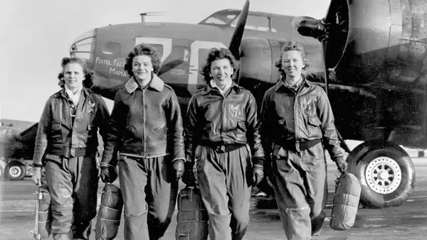
Women ferry pilots flew planes from the point of manufacture to a military airfield where they would either be used or flown to overseas locations via one of the ferry routes.
Women ferry pilots flew within the mainland United States only. They did not ferry aircraft to Alaska or other countries.

Sources
Wikipedia: North Atlantic air ferry route in World War II
South Atlantic air ferry route in World War II
South Pacific air ferry route in World War II
Air Ferry Routes of World War II
The World War II Heritage of Ladd Field, Fairbanks, Alaska
The Soviet PBY Catalinas of WWII
Pipeline to Russia :the Alaska-Siberia Air Route in World War II
The Veil is Lifted: Fisherman’s Lake, Liberia, PAA Builds a Seaport in the Jungle
Lend Lease Tanks in the Soviet Union
Author Katherine Lanndeck on the Life of a WWII Ferry Pilot
The Originals: The Women's Auxiliary Ferrying Squadron of World War II by Sarah Byrn Rickman
The Floyd Bennett Field Task Force: Naval Air Ferry Command 1943-1945